


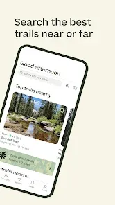
Ever felt the urge to explore a new trail but weren't sure where to go, how difficult it would be, or if the views would be worth the effort? AllTrails: Hike, Bike & Run is the ultimate outdoor companion for millions of adventurers, transforming your smartphone into a detailed trail guide and navigation tool. With the world's largest collection of hand-curated trail maps—over 400,000 trails across the globe—you can discover perfect paths for hiking, mountain biking, running, and backpacking. Filter by length, elevation gain, rating, and activity type, read reviews and see photos from fellow outdoor enthusiasts, and navigate with confidence using detailed offline maps. It's your key to unlocking adventure, one trail at a time.
Why You'll Love AllTrails
AllTrails removes the guesswork from outdoor exploration, combining community-driven insights with professional-grade mapping tools.
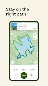
- Massive, Curated Trail Database: Find the perfect trail near you or plan a trip anywhere in the world. Detailed listings include distance, elevation profile, estimated time, difficulty, and user-generated photos and reviews.
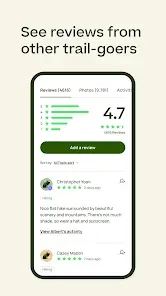
- Community Reviews & Recent Conditions: Make informed decisions by reading recent trail reports. Find out about mud, snow, bugs, trail closures, and whether the waterfall is flowing before you head out.
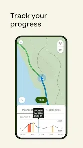
- Offline Maps & GPS Navigation (Pro Feature): Download trail maps for offline use, a critical feature for areas with no cell service. The app's GPS tracker shows your real-time location on the map, so you can't get lost.
- Customizable Filters & Lists: Search for exactly what you want: dog-friendly trails, kid-friendly hikes, wheelchair-accessible paths, wildflower meadows, or epic summit views. Save favorites to personal lists like "Weekend Adventures" or "Post-Rainfall Hikes."
Core Features That Make a Difference
The app includes advanced tools for safety, planning, and tracking your outdoor achievements.
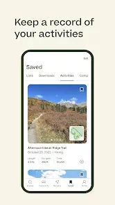
- Record Your Adventures: Use your phone's GPS to record your hike, bike, or run. Track stats like distance, elevation gain, moving time, and average speed. Save and share your recordings.
- Lifeline Safety Feature (Pro): Share your real-time location with loved ones via a unique link before you head out on a solo adventure. They can see your progress and estimated finish time for peace of mind.
- Trail Overlays & Map Layers (Pro): Enhance your downloaded maps with overlays like satellite view, heatmaps (showing popular routes), and air quality information. The 3D map feature previews the terrain.
- Integration with Wearables & Health Apps: Sync your activities with Apple Health, Google Fit, Garmin, and other wearables to consolidate all your fitness data in one place.
How to Use AllTrails and Get Started Today
Finding your next adventure and navigating it safely is a simple, step-by-step process.
- Click “Check All Versions” below to download and install AllTrails: Hike, Bike & Run on your device or browser.
- Open the app and allow location access. The home screen will immediately show popular trails near you.
- Use the search or filter functions to narrow down trails. Read recent reviews and look at photos to choose one that matches your ability and expectations.
- Before you leave, tap "Download" on the trail map if you're going somewhere with poor service (an AllTrails Pro feature). Ensure your phone is charged.
- At the trailhead, tap "Navigate" or "Start Recording" to begin. Follow your location on the map. Stick to the marked trail to protect the environment and stay safe.
- After your trip, save your recording, add your own review and photos to help the community, and rate the trail. Share your adventure with friends!
 0
0